
Final Polar Vortex Split: Late-Winter Stratospheric Wind Reversal Is Coming, Impacting the Weather into March
Meteorologists warn of potential cold snaps and shifting storm tracks as upper-atmosphere winds prepare to flip
A dramatic shift is unfolding high above the Arctic — one that could shape weather patterns across the Northern Hemisphere well into March. Meteorologists are closely monitoring what is being described as the final polar vortex split of the season, accompanied by a late-winter stratospheric wind reversal.
While the event is occurring nearly 30 miles above Earth’s surface, its effects could ripple downward, influencing temperature swings, storm systems, and even prolonged cold spells in parts of North America, Europe, and Asia.
But what exactly is happening — and why does it matter?
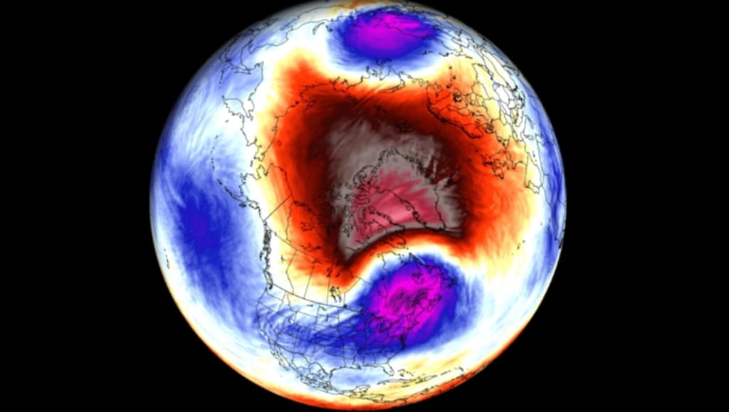
What Is the Polar Vortex?
The polar vortex is a large, rotating mass of cold air that forms over the Arctic each winter. It is driven by strong westerly winds in the stratosphere — the atmospheric layer above where most weather occurs.
When the vortex is strong and stable, cold air remains largely confined to polar regions. However, when it weakens or becomes disrupted, Arctic air can spill southward into mid-latitude regions.
These disruptions are often linked to significant winter weather events.
What Does a “Vortex Split” Mean?
A polar vortex split occurs when the single circulation divides into two smaller centers of low pressure. Instead of one dominant swirl over the Arctic, the system fragments.
This split is usually triggered by disturbances in atmospheric wave patterns originating lower in the atmosphere. When those waves intensify, they push upward into the stratosphere, disrupting the vortex’s stability.
The result? A dramatic shift in stratospheric wind patterns — including a reversal from westerly to easterly flow.
Stratospheric Wind Reversal Explained
During a stratospheric wind reversal, the typical west-to-east winds around the pole weaken and flip direction.
This process is often associated with a Sudden Stratospheric Warming (SSW) event, during which temperatures in the stratosphere can rise sharply over just a few days.
Although this warming happens high above, its impact can cascade downward over one to three weeks.
Forecasters say this late-winter reversal appears strong enough to influence surface weather patterns into March.
Why Late-Winter Timing Matters
The timing of this event is particularly important.
Early-season vortex disruptions often produce widespread cold outbreaks. However, a late-winter split — such as this one — can extend winter’s grip just as many regions anticipate seasonal transition.
In some cases, March can turn colder than February following a vortex breakdown.
Meteorologists caution that not every vortex split guarantees extreme weather, but historical patterns show a higher likelihood of colder-than-average conditions in parts of the U.S. Midwest, the northeastern United States, northern Europe, and East Asia.
Potential Weather Impacts
While exact outcomes remain uncertain, possible impacts include:
Colder-than-normal temperatures across mid-latitude regions
Increased snowfall potential in susceptible areas
Shifts in the jet stream pattern
Enhanced storm development
The jet stream — a fast-moving river of air in the upper atmosphere — often becomes more wavy during vortex disruptions. This allows Arctic air to plunge south while milder air surges northward elsewhere.
As a result, weather contrasts can become more pronounced.
Europe and North America in Focus
Current forecast models suggest the effects may become noticeable by late February and persist into early March.
In Europe, northern and central regions could see cooler-than-average conditions, while southern areas might experience variable patterns.
In North America, some meteorologists are watching for potential cold outbreaks in the Midwest and Northeast.
However, long-range forecasting remains complex. The atmosphere does not always respond uniformly to stratospheric signals.
Why Forecasting Is Challenging
Stratosphere-to-surface coupling — the process by which upper-level changes affect ground-level weather — does not happen instantly.
It can take days or weeks for atmospheric adjustments to propagate downward.
Additionally, other factors influence weather outcomes, including ocean temperatures, regional pressure systems, and ongoing climate trends.
This means that while a vortex split increases the probability of certain patterns, it does not guarantee them.
Climate Context
Scientists are also studying how climate change may influence polar vortex behavior.
Some research suggests that Arctic warming could weaken the vortex more frequently, potentially increasing the likelihood of disruptions.
However, this remains an area of active scientific debate.
What is clear is that polar vortex events have occurred long before modern climate shifts — they are natural atmospheric processes.
Public Misconceptions
The term “polar vortex” often sparks dramatic headlines, but it is not a new phenomenon.
The vortex exists every winter. It is the disruption — not the presence — that attracts attention.
Similarly, a vortex split does not mean constant snowstorms everywhere. Some regions may experience mild or even warmer conditions depending on how the jet stream shifts.
Balanced interpretation is essential.
What to Watch in the Coming Weeks
Meteorologists will monitor:
The strength of the wind reversal
The position of the jet stream
Temperature anomalies across the Arctic
Pressure patterns over North America and Europe
If stratospheric changes successfully couple with lower atmospheric layers, March could deliver renewed winter-like conditions in certain regions.
Preparing for Weather Swings
For residents in potentially affected areas, staying informed is key.
Late-season cold snaps can impact:
Agriculture and early planting
Energy demand
Travel conditions
Infrastructure
Meteorological agencies advise monitoring official forecasts rather than relying solely on long-range projections circulating online.
A Reminder of Atmospheric Complexity
The final polar vortex split of the season serves as a powerful example of Earth’s atmospheric complexity.
Events occurring tens of kilometers above the surface can influence daily weather patterns weeks later.
As the stratospheric wind reversal unfolds, forecasters will refine predictions based on evolving data.
Conclusion
The anticipated late-winter polar vortex split and stratospheric wind reversal could reshape weather patterns into March, potentially bringing colder air and dynamic storm systems to parts of the Northern Hemisphere.
While uncertainties remain, the event highlights the interconnected nature of atmospheric layers and the importance of advanced forecasting tools.
As winter makes its final push, meteorologists — and millions watching the forecast — will be tracking how this upper-atmosphere shift translates into conditions on the ground.
For now, the message is clear: winter may not be finished just yet.
About the Creator
Keep reading
More stories from Aarif Lashari and writers in Geeks and other communities.
Russia’s Extreme Winter Storms Are a Climate Wake-Up Call the Kremlin Is Ignoring
Russia has recently experienced increasingly extreme winter storms, raising concerns among climate scientists, environmental researchers, and global policy observers. Some analysts argue these severe weather patterns should serve as a climate warning for policymakers, while critics claim current responses remain focused on short-term economic priorities rather than long-term environmental planning.
By Aarif Lashari25 days ago in Geeks
A Knight of the Seven Kingdoms Series Review (Season 1)
As one of the biggest properties in fantasy, A Song of Ice and Fire remains immensely popular with audiences. After reaching far into the past with House of the Dragon, a second spin-off was on the cards. A Knight of the Seven Kingdoms serves up a bite-sized slice of action and drama, but it still claims a spot among the best small-screen titles.
By Robert Cainabout 21 hours ago in Geeks


Comments
There are no comments for this story
Be the first to respond and start the conversation.