
New Snowfall Map: Late Sunday–Monday Nor’easter Expected to Bring Heavy Snow to Massachusetts
Forecasters warn of significant accumulations, strong coastal winds, and hazardous travel across much of the Bay State
A powerful late-season nor’easter is taking aim at Massachusetts, with meteorologists projecting heavy snowfall from late Sunday night through Monday afternoon. Updated snowfall maps show widespread accumulation potential across central and eastern portions of the state, raising concerns about treacherous travel, coastal wind gusts, and localized power outages.
While winter storms are hardly unusual in New England, this system stands out for both its timing and projected intensity. Coming as many residents begin anticipating early signs of spring, the storm is a reminder that March and even late February can still deliver full-scale winter conditions.
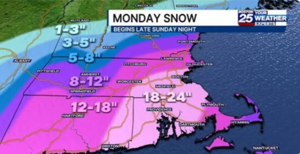
What the Latest Snowfall Maps Show
Forecast models indicate that the heaviest snow bands are likely to set up across central Massachusetts, with several inches possible in cities such as Worcester and surrounding communities. Eastern Massachusetts — including the Greater Boston region — could also see substantial snowfall totals depending on how the storm track evolves overnight Sunday.
Coastal areas may experience a mix of rain and wet snow at times, particularly during the early stages of the storm. However, as colder air wraps into the system, precipitation is expected to transition to all snow in many locations.
Northern and western parts of the state could also see steady snowfall, though slight shifts in the storm’s path may influence final totals. Even a modest deviation of 25 to 50 miles east or west could significantly alter accumulation patterns.
Why This Nor’easter Matters
Nor’easters are named for the strong northeasterly winds that typically accompany them. These storms form along the East Coast when cold continental air collides with warmer, moisture-rich Atlantic air. The resulting low-pressure system can intensify rapidly — sometimes in a process known as “bombogenesis,” where pressure drops sharply over 24 hours.
This particular storm is expected to strengthen offshore, pulling moisture inland while cold air remains locked in place across much of Massachusetts. The combination sets the stage for heavy, potentially wet snowfall — the kind that clings to tree branches and power lines.
In addition to snow accumulation, forecasters are monitoring:
Wind gusts that could exceed 40 mph along the coast
Reduced visibility during periods of heavy snowfall
Slushy to snow-covered roadways during the Monday commute
Minor coastal flooding during high tide cycles
Travel Impacts Likely
The storm’s timing is especially disruptive. Snow is forecast to begin late Sunday evening, becoming steadier overnight and continuing into Monday morning. That places the height of the system squarely during the Monday commute.
Major roadways such as Interstate 90 (Mass Pike), Interstate 95, and Route 128 may see hazardous driving conditions. State and local highway crews are expected to pre-treat roads ahead of the storm, but heavy snowfall rates could outpace plowing efforts at times.
Air travel may also be affected, particularly at Boston Logan International Airport. Nor’easters often lead to flight delays and cancellations due to low visibility and runway clearing requirements.
Public officials are urging residents to:
Avoid unnecessary travel during peak snowfall
Keep emergency kits in vehicles
Allow extra time for commuting
Monitor local weather updates throughout the event
Wet Snow Raises Power Outage Risk
Unlike lighter, powdery snow typical of mid-winter cold snaps, this storm may produce heavier, moisture-laden snow — especially across eastern Massachusetts. Wet snow adheres more easily to trees and utility lines, increasing the risk of downed branches and scattered outages.
If strong wind gusts coincide with peak snowfall, isolated power interruptions could develop, particularly in coastal communities and wooded inland areas.
Utility companies typically stage crews ahead of major storms, and residents are encouraged to charge devices and prepare backup power sources if available.
Coastal Concerns
In addition to inland snowfall, the nor’easter’s onshore winds could generate rough surf and minor coastal flooding. Shoreline communities along Cape Cod, the South Shore, and parts of the North Shore may experience splash-over during high tide.
Beach erosion is also possible if strong wave action persists for several tidal cycles. Local emergency management agencies are monitoring tidal forecasts closely.
Schools and Business Closures Possible
Depending on final snowfall totals, some school districts may consider delayed openings or closures on Monday. Businesses that rely heavily on in-person operations may also adjust schedules.
Remote work flexibility, now more common than in years past, could reduce commuter volume — but those required to travel should remain cautious.
How This Storm Compares to Past Nor’easters
Massachusetts has experienced numerous high-impact winter storms in recent decades. While it remains too early to classify this event among the most severe, it shares key ingredients with classic New England snowmakers:
Coastal low-pressure development
Deep Atlantic moisture feed
Cold inland air mass
Strong wind fields
The final intensity will depend heavily on the storm’s exact track. If it strengthens slightly closer to shore, snowfall totals could climb. If it remains farther offshore, coastal mixing could reduce accumulation in some eastern communities.
Forecast Uncertainty Still Exists
As with any dynamic winter system, forecast models may continue to adjust as new atmospheric data becomes available. Meteorologists emphasize that snowfall maps represent projections based on current data — not guarantees.
Residents should pay attention to updated advisories and potential winter storm warnings. Even a small change in surface temperatures could determine whether certain areas see heavy snow or a rain-snow mix.
Preparing for the Storm
With several inches of snow possible across much of the state, preparation is key. Residents are encouraged to:
Stock up on groceries and essentials before Sunday evening
Ensure snow removal equipment is operational
Check heating systems and fuel supplies
Keep flashlights and batteries accessible
Move vehicles off streets where parking bans may be implemented
Homeowners should also clear storm drains where possible to reduce localized flooding from melting snow.
Looking Ahead
Once the storm moves offshore Monday afternoon or evening, colder air may settle in behind it. That could allow any untreated surfaces to refreeze overnight, prolonging hazardous conditions into Tuesday morning.
While spring officially approaches, New England’s climate has long demonstrated that winter can linger. This late Sunday–Monday nor’easter serves as another example of the region’s unpredictable seasonal transitions.
For now, the message from forecasters is clear: prepare for significant snowfall, monitor official updates, and plan for potential disruptions as Massachusetts braces for another classic winter storm.
About the Creator
10 Times Tourists Completely Ruined Priceless History
There’s something magnetic about ancient architecture and historic artifacts. Whether it’s a crumbling amphitheater, a sacred temple high in the mountains, or a centuries-old painting in a quiet chapel, we’re drawn to these places. Maybe it’s the mystery. Maybe it’s the legends. Maybe it’s the simple realization that these structures have survived hundreds, sometimes thousands of years.
By Areeba Umair6 days ago in Wander


Comments
There are no comments for this story
Be the first to respond and start the conversation.